Lunar Surface Navigation System
Robotics Automation and Control
Lunar Surface Navigation System (LAR-TOPS-361)
Reverse-ephemeris approach enables low-cost lunar navigation solution
Overview
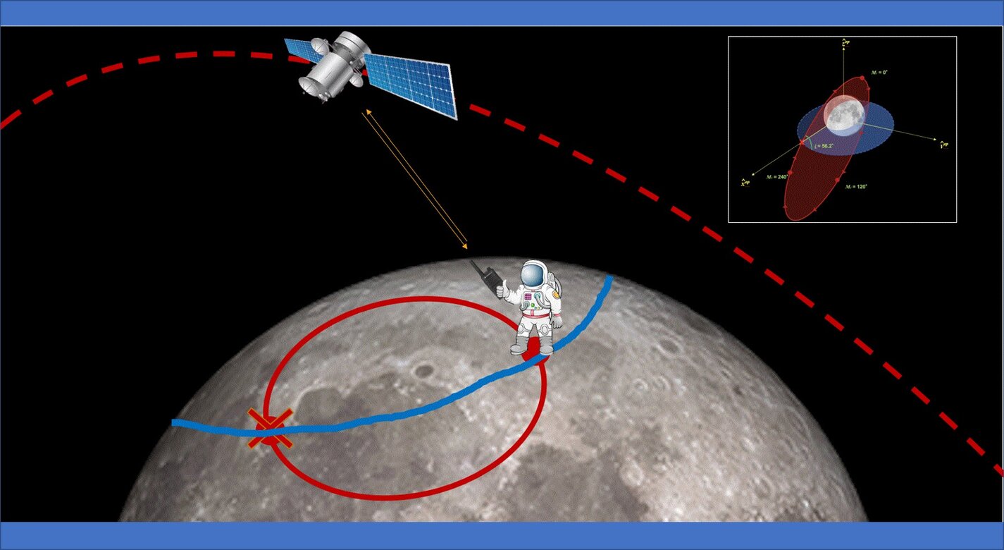
Scientists at NASA’s Langley Research Center have developed a novel concept for a lunar navigation system based on the reverse-ephemeris technique. Typically, range related signal measurements from the earth’s surface are used to locate and track orbital objects (satellites) and establish the ephemeris describing their orbits. For this reverse-ephemeris lunar navigation concept, the process is reversed to give lunar surface position fixes using the known ephemeris of a satellite in lunar orbit. Only a few inexpensive smallsats are required in order to implement a lunar navigation system based on this concept.
Lunar navigation systems will be needed for future moon missions, including for example for rover navigation, mining operations, exploration, etc. The inventors have conducted analytical simulations to demonstrate the versatility of this innovation when used to support route determination for various autonomous or manned lunar surface operations.
The Technology
NASA’s reverse-ephemeris lunar navigation system is a concept for determining position on the lunar surface based on known orbits of satellites. In conventional GPS navigation systems, the GPS satellite transmits ephemeris data to a receiver on earth for determining position at the receiver location. Whereas for the reverse-ephemeris approach the receiver becomes the transmitter, and the satellite instead serves more as a fixed reference position with a known ephemeris. This simplifies the satellite requirements and also mitigates potential navigational disruptions that can otherwise arise in navigation systems that utilize satellite-based communications, for example from interference, jamming, etc.
The design consists of lunar surface S-Band (2,400 – 2,450 MHz) 10 W transceivers ranging with analog translating transponders on a three-satellite constellation in frozen elliptical orbits to provide continuous coverage with service to 300 simultaneous users over 1.8 MHz of bandwidth at the transponder. Digital bases systems are possible too. As compared to GPS-based navigation requiring four or more satellites costing 100’s of millions of dollars, the new NASA concept is based on using only three smallsats.


Benefits
- Minimal investment needed to develop and validate
- Low-cost of implementation; only 3 smallsats needed
- Effective and robust navigation for lunar surface missions
Applications
- Lunar: Navigational support for exploration, construction, mining, and other lunar surface activities.
Similar Results

eVTOL UAS with Lunar Lander Trajectory
This NASA-developed eVTOL UAS is a purpose-built, electric, reusable aircraft with rotor/propeller thrust only, designed to fly trajectories with high similarity to those flown by lunar landers. The vehicle has the unique capability to transition into wing borne flight to simulate the cross-range, horizontal approaches of lunar landers. During transition to wing borne flight, the initial transition favors a traditional airplane configuration with the propellers in the front and smaller surfaces in the rear, allowing the vehicle to reach high speeds. However, after achieving wing borne flight, the vehicle can transition to wing borne flight in the opposite (canard) direction. During this mode of operation, the vehicle is controllable, and the propellers can be powered or unpowered.
This NASA invention also has the capability to decelerate rapidly during the descent phase (also to simulate lunar lander trajectories). Such rapid deceleration will be required to reduce vehicle velocity in order to turn propellers back on without stalling the blades or catching the propeller vortex. The UAS also has the option of using variable pitch blades which can contribute to the overall controllability of the aircraft and reduce the likelihood of stalling the blades during the deceleration phase.
In addition to testing EDL sensors and precision landing payloads, NASA’s innovative eVTOL UAS could be used in applications where fast, precise, and stealthy delivery of payloads to specific ground locations is required, including military applications. This concept of operations could entail deploying the UAS from a larger aircraft.

Goddard's Reconfigurable Laser Ranger (GRLR)
NASA Goddard Space Flight Center has developed a low cost, modular, and flexible space flight laser range finder consisting of optics, electronics, and interfaces for satellite servicing missions (i.e. Restore-L) using customized optics. Built upon previous NASA technologies, the system also consists of a high dynamic range receiver and adjustable laser for a wide range of measurements (i.e. multiples of km to sub-meter).

Low Cost Star Tracker Software
The current Star Tracker software package is comprised of a Lumenera LW230 monochrome machine-vision camera and a FUJINON HF35SA-1 35mm lens. The star tracker cameras are all connected to and powered by the PC/104 stack via USB 2.0 ports. The software code is written in C++ and is can easily be adapted to other camera and lensing platforms by setting new variables in the software for new focal conditions. In order to identify stars in images, the software contains a star database derived from the 118,218-star Hipparcos catalog [1]. The database contains a list of every star pair within the camera field of view and the angular distance between those pairs. It also contains the inertial position information for each individual star directly from the Hipparcos catalog. In order to keep the star database size small, only stars of magnitude 6.5 or brighter were included. The star tracking process begins when image data is retrieved by the software from the data buffers in the camera. The image is translated into a binary image via a threshold brightness value so that on (bright) pixels are represented by 1s and off (dark) pixels are represented by 0s. The binary image is then searched for blobs, which are just connected groups of on pixels. These blobs represent unidentified stars or other objects such as planets, deep sky objects, other satellites, or noise. The centroids of the blob locations are computed, and a unique pattern recognition algorithm is applied to identify which, if any, stars are represented. During this process, false stars are effectively removed and only repeatedly and uniquely identifiable stars are stored. After stars are identified, another algorithm is applied on their position information to determine the attitude of the satellite. The attitude is computed as a set of Euler angles: right ascension (RA), declination (Dec), and roll. The first two Euler angles are computed by using a linear system that is derived from vector algebra and the information of two identified stars in the image. The roll angle is computed using an iterative method that relies on the information of a single star and the first two Euler angles.
[1] ESA, 1997, The Hipparcos and Tycho Catalogues, ESA SP-1200

Space Link Extension Return Channel Frames (SLE-RCF) Software Library
The Space Link Extension Return Channel Frames (SLE-RCF) software library helps to monitor the health and safety of spacecraft by enabling space agency ground support and mission control centers to develop standardized and interoperable mission control applications for space telemetry data. The software library eliminates the need for missions to implement custom data communication designs to communicate with any ground station. The two main tasks accomplished via the SLE-RCF software library are processing user requests and receiving data from ground stations and ground support assets.
The software library contains three layers:
-SLE (Space Link Extension) for the abstract workings of the protocol
-DEL (Decoding and Encoding Layer) to decode and encode the abstract messages used by the SLE layer
-TML (Transport Mapping Layer) to transfer the encoded messages via some underlying transport layer protocol, such as as the transmission control protocol (TCP)
The library accepts configuration or SLE-RCF directives from the user and responds accordingly. Incoming data, both telemetry frames and status messages, are processed and the appropriate callback routines are triggered by the library.

Space Optical Communications Using Laser Beams
This invention provides a new method for optical data transmissions from satellites using laser arrays for laser beam pointing. The system is simple, static, compact, and provides accurate pointing, acquisition, and tracking (PAT). It combines a lens system and a vertical-cavity surface-emitting laser VCSEL)/Photodetector Array, both mature technologies, in a novel way for PAT. It can improve the PAT system's size, weight, and power (SWaP) in comparison to current systems. Preliminary analysis indicates that this system is applicable to transmissions between satellites in low-Earth orbit (LEO) and ground terminals. Computer simulations using this design have been made for the application of this innovation to a CubeSat in LEO. The computer simulations included modeling the laser source and diffraction effects due to wave optics. The pointing used a diffraction limited lens system and a VCSEL array. These capabilities make it possible to model laser beam propagation over long space communication distances. Laser beam pointing is very challenging for LEO, including science missions. Current architectures use dynamical systems, (i.e., moving parts, e.g., fast-steering mirrors (FSM), and/or gimbals) to turn the laser to point to the ground terminal, and some use vibration isolation platforms as well. This static system has the potential to replace the current dynamic systems and vibration isolation platforms, dependent on studies for the particular application. For these electro-optical systems, reaction times to pointing changes and vibrations are on the nanosecond time scale, much faster than those for mechanical systems. For LEO terminals, slew rates are not a concern with this new system.


