Dynamic Weather Routes Tool
aerospace
Dynamic Weather Routes Tool (TOP2-168)
An automated corrections to weather avoidance routes for aircraft in en-route airspace
Overview
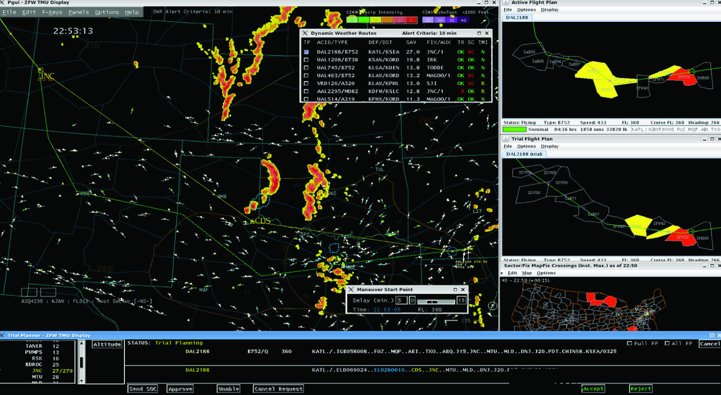
NASA has developed a ground-based aircraft flight automation system and tool that can save significant amounts of time and fuel in challenging weather situations. The Dynamic Weather Routes (DWR) tool continuously and automatically analyzes in-flight aircraft in en-route airspace to find corrections to preselected weather avoidance routes. Convective weather, such as severe thunderstorm activity, is the largest cause of delay in the U.S. National Airspace System. When such weather is present or forecast on preferred flight routes, weather avoidance routes are selected before takeoff. They often include large buffers to compensate for forecast uncertainty. As flights progress, airline dispatchers and Federal Aviation Administration (FAA) traffic managers strive to find improved routes to reduce delay. However, operators are busy, especially during weather events, and may miss opportunities for more time-and-fuel-efficient routes. Automation hasn't previously existed to help operators determine when weather avoidance routes could be modified or eliminated to reduce delay.
The Technology
Every 12 seconds, the Dynamic Weather Route (DWR) automation system computes and analyzes trajectories for en-route flights. DWR first identifies flights that could save 5 or more flying minutes (wind-corrected) by flying direct to a downstream return fix on their current flight plan. Eligible return fixes are limited so as not to take flights too far off their current route or interfere with arrival routings near the destination airport. Using the direct route as a reference route, DWR inserts up to two auxiliary waypoints as needed to find a minimum-delay reroute that avoids the weather and returns the flight to its planned route at the downstream fix. If a reroute is found that can save 5 minutes or more relative to the current flight plan, the flight is posted to a list displayed to the airline or FAA user. Auxiliary waypoints are defined using fix-radial-distance format, and a snap to nearby named fix option is available for todays voice-based communications. Users may also adjust the alert criteria, nominally set to 5 minutes, based on their workload and desired potential savings for their flights. A graphical user interface enables visualization of proposed routes on a traffic display and modification, if necessary, using point, click, and drag inputs. If needed, users can adjust the reroute parameters including the downstream return fix, any inserted auxiliary waypoints, and the maneuver start point. Reroute metrics, including flying time savings (or delay) relative to the current flight plan, proximity to current and forecast weather, downstream sector congestion, traffic conflicts, and conflicts with special use airspace are all updated dynamically as the user modifies a proposed route.


Benefits
- Real-time automation finds high-value reroute options
- Time and flight efficiency
- Fuel savings
- Rapid feedback Interactive user interface for visualization and analysis
- Auto formatted for updates
- Wind-corrected flying time analysis
- Minimum-delay weather avoidance
- Minimum-delay conflict resolutions
- Integration of many factors relevant to airborne reroutes
Applications
- Air traffic management
- Airline flight dispatch operations
Technology Details
aerospace
TOP2-168
ARC-16846-1
For more information go to:
http://www.aviationsystemsdivision.arc.nasa.gov/research/strategic/dwr.shtml
|
Tags:
|
Similar Results

Flight Awareness Collaboration Tool (FACT)
The Flight Awareness Collaboration Tool (FACT) user interface is a quad design with four areas. The Primary Map View shows the US with several traffic and weather overlays. The Surface Map View displays the selected airport with information on runway conditions and other factors. The Information View has specific data from various sources about the area of interest. This view also has a built-in algorithm that predicts the impact of the forecast winter weather on airport capacity. The Communication View supports messaging within the geographically-dispersed team that is using FACT. When an airport is selected in the Primary Map View, the information presented in the Surface Map and Information Views is focused on that choice.
FACT is a web-based application using Node.js and MongoDB. It receives Java messages from the Federal Aviation Administration System Wide Information Management (SWIM) data repository. Data acquired from web pages and SWIM are tailored for FACTs Information View area. FACT is designed to reside on an existing workstation monitor to be put into use as needed.

Digital Twin Simulator of the National Airspace System (NAS)
The digital twin NAS simulator provides a complete digital copy of the individual systems that comprise the NAS to allow for the creation of offline simulations to test proposed changes to one or more individual systems based on actual historical data from the NAS or on real-time data from the NAS. The NAS is composed of a collection of systems, including source systems such as weather stations from various locations or airports, which are used by other systems such as individual aircraft flight data and airline operators. Other systems may include management systems such as the FAA, air traffic control centers, and flight traffic monitors. Operational data from each of these systems may be archived by a central information sharing platform such as the System Wide Information Management (SWIM) Program operated by the FAA. The digital twin NAS simulator can access archived SWIM data to create a digital twin NAS system to provide a virtual environment that may operate in real-time alongside the actual NAS, with the digital twin receiving live data updates from the actual NAS. A dedicated application programming interface (API) is used to facilitate communication between various distributed external components and the testbed. The testbed receives NAS data during a test and feeds the data to the simulation manager for use with a digital twin of the NAS system. The result is a virtual environment that is an exact twin of the actual operational system and is able to function identically to the actual NAS system because it is based on and uses the same data archived from the actual NAS system. A primary function of the virtual twin NAS is that it will allow for changes to one or more systems to be simulated against the archived NAS data and subsequently allow for a comparison between the simulated results and the actual results from the operational system. The digital twin simulator may also function in a distributed network environment, allowing for simulations of different elements to run simultaneously, which speeds up and improves the testing and evaluation of proposed changes.

Traffic Aware Strategic Aircrew Requests (TASAR)
The NASA software application developed under the TASAR project is called the Traffic Aware Planner (TAP). TAP automatically monitors for flight optimization opportunities in the form of lateral and/or vertical trajectory changes. Surveillance data of nearby aircraft, using ADS-B IN technology, are processed to evaluate and avoid possible conflicts resulting from requested changes in the trajectory. TAP also leverages real-time connectivity to external information sources, if available, of operational data relating to winds, weather, restricted airspace, etc., to produce the most acceptable and beneficial trajectory-change solutions available at the time. The software application is designed for installation on low-cost Electronic Flight Bags that provide read-only access to avionics data. The user interface is also compatible with the popular iPad. FAA certification and operational approval requirements are expected to be minimal for this non-safety-critical flight-efficiency application, reducing implementation cost and accelerating adoption by the airspace user community.
Awarded "2016 NASA Software of the Year"

Mitigating Risk in Commercial Aviation Operations
NASA’s newly developed software leverages flight operations data (e.g., SWIM Terminal Data Distribution System (STDDS) information), and with it, can predict aviation related risks, such as unstable approaches of flights. To do this, the software inputs the complex, multi-source STDDS data, and outputs novel prediction and outcome information.
The software converts the relatively inaccessible SWIM data from its native format that is not data science friendly into a format easily readable by most programs. The converted, model friendly data are then input into machine learning algorithms to enable risk prediction capabilities. The backend software sends the machine learning algorithm results to the front end software to display the results in appropriate user interfaces. These user interfaces can be deployed on different platforms including mobile phones and desktop computers and efficiently update models based on changes in the data.
To allow for visualization, the software uses a commercially available mapping API. The data are visualized in several different ways, including a heat map layer that shows the risk score, with higher risk in areas of higher flight density, a polyline layer, which shows flight paths, and markers that can indicate a flight’s location in real time, among other things. The related patent is now available to license. Please note that NASA does not manufacturer products itself for commercial sale.

Method and System for Air Traffic Rerouting for Air-space Constraint Resolution
National Airspace System (NAS) Constraint Evaluation and Notification Tool (NASCENT) employs a NAS-wide simulation and analysis infrastructure that implements airspace constraint avoidance algorithms for efficient routing. NASCENT uses NASA-developed aircraft performance tables for computing climb, cruise, and descent trajectories. Reference routes are created that save more than a user-specified number (e.g., five) minutes of flying-time savings. The return capture fix for the reference route is the last fix on the current flight plan within a limit region (derived using this patented technology). A Maneuver Start Point is selected to allow time for coordination of the reroute with the Federal Aviation Administration (FAA). These routes are checked against the weather polygons, FAA denoted Special Use Airspaces (e.g., Military Operations Areas) and Temporary Flight Restrictions (TFRs); and additional waypoints are added to avoid these airspace constraints. The wind-corrected flying-time savings are reported for each flight. The polygons are first converted into convex hulls and inflated by a user-specified number of nautical miles (e.g., 20, for weather) to account for the FAA requirements. Lateral and/or vertical advisories are created using a binary tree search along the left-side and right-side, up to the return capture fix, to find a minimum-deviation delay solution. The NASCENT system provides notification for congested sectors along the current flight plan and the proposed avoidance route, along with flights impacted by FAA imposed required Traffic Management Initiatives (TMIs, reroutes, Ground Delay Programs, etc.). The reroutes can be implemented with no changes required to the current FAA operational infrastructure.


