Hierarchical Image Segmentation (HSEG)
information technology and software
Hierarchical Image Segmentation (HSEG) (GSC-TOPS-14)
Enhancing image processing using Earth imaging software from NASA
Overview
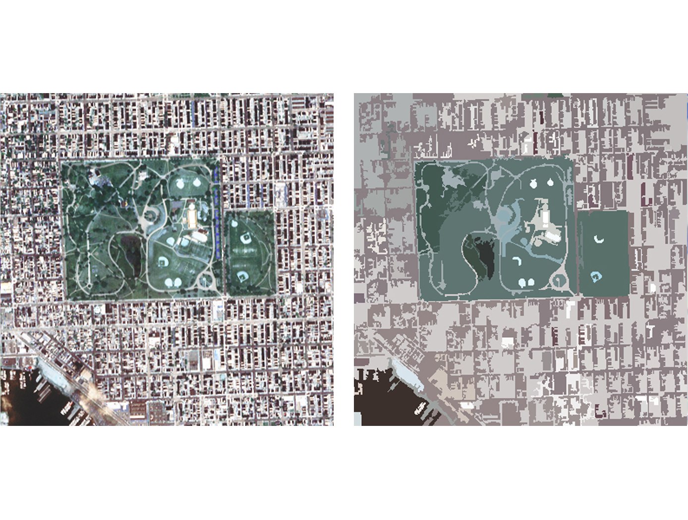
Hierarchical Image Segmentation (HSEG) software was originally developed to enhance and analyze images such as those taken of Earth from space by NASAs Landsat and Terra missions.
The HSEG software analyzes single band, multispectral, or hyperspectral image data and can process any image with a resolution up to 8,000 x 8,000 pixels, then group the pixels that have similar characteristics to form regions, and ultimately combines regions based on their similarity, whether adjacent or disjointed. This grouping creates spatially disjoint regions. The software is accompanied by HSEGViewer, a companion visualization and segmentation selection tool that can be used to highlight and select data points from particular regions.
The Technology
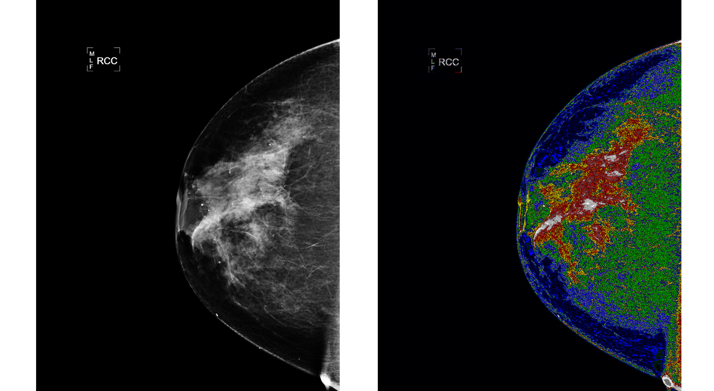
Currently, HSEG software is being used by Bartron Medical Imaging as a diagnostic tool to enhance medical imagery. Bartron Medical Imaging licensed the HSEG Technology from NASA Goddard adding color enhancement and developing MED-SEG, an FDA approved tool to help specialists interpret medical images.
HSEG is available for licensing outside of the medical field (specifically for soft-tissue analysis).


Benefits
- Faster than competing software
- Improves analytical capabilities with increase speed over state-of-the-art
- Refined results, maximum flexibility and control
- User-friendly GUI
Applications
- Image pre-processing (specifically, segmentation)
- Image data mining
- Crop monitoring
- Medical Image analysis enhancements (Mammography, X-Rays, CT, MRI, and Ultrasound)
- Facial recognition
|
Tags:
|
Similar Results

Update of the Three Dimensional Version of RHSeg and HSeg
Image data is subdivided into overlapping sections. Each image subsection has an extra pixels forming an overlapping seam in the x, y, and z axes. The region labeling these overlapping seams are examined and a histogram is created of the correspondence between region labels across image subsections. A region from one subsection is then merged together with a region from another subsection when specific criterion is met.
This innovations use of slightly overlapping processing windows eliminates processing window artifacts. This innovative approach can be used by any image segmentation or clustering approach that first operates on subsections of data and later combines the results from the subsections together to produce a result for the combined image.

Grid-Oriented Normalization for Analysis of Spherical Areas (GONASA)
NASA's GONASA technology is a mathematical formula / algorithm built around creating a grid composed of equal-area cells that span the entire visible hemisphere of a spherical object. Traditional longitude and latitude grids produce cells that diminish in size toward the poles due to convergence of longitudinal lines. GONASA circumvents this problem by carefully adjusting the latitude increments, resulting in a network of truly equal-area cells. This adjustment ensures that any feature observed on the spherical surface is accurately represented, regardless of its location.
To implement GONASA, the spherical surface is first segmented into discrete latitude bands or rings, each chosen to encompass an identical surface area. Within each ring, longitude divisions maintain equal cell areas, creating a uniform Cartesian grid. The result is a consistent, distortion-corrected matrix suitable for automatic computation, enabling simplified, efficient, and accurate measurements of spatial characteristics such as feature area, centroid location, perimeter, compactness, orientation, and aspect ratio.
GONASA grids are computationally efficient and readily adaptable to a range of data processing workflows, from spreadsheets to sophisticated data analysis frameworks like Pandas data frames in Python. Due to their consistent cell sizing and straightforward indexing, GONASA grids facilitate automation, enabling rapid, high-volume data processing and analysis, essential for modern remote sensing and planetary missions that require immediate, reliable data analysis in limited-bandwidth communications environments. At NASA, GONASA has already been successfully implemented to study images of Titan (e.g., mapping its clouds) taken by the Cassini space probe.

Computational Visual Servo
The innovation improves upon the performance of passive automatic enhancement of digital images. Specifically, the image enhancement process is improved in terms of resulting contrast, lightness, and sharpness over the prior art of automatic processing methods. The innovation brings the technique of active measurement and control to bear upon the basic problem of enhancing the digital image by defining absolute measures of visual contrast, lightness, and sharpness. This is accomplished by automatically applying the type and degree of enhancement needed based on automated image analysis.
The foundation of the processing scheme is the flow of digital images through a feedback loop whose stages include visual measurement computation and servo-controlled enhancement effect. The cycle is repeated until the servo achieves acceptable scores for the visual measures or reaches a decision that it has enhanced as much as is possible or advantageous. The servo-control will bypass images that it determines need no enhancement.
The system determines experimentally how much absolute degrees of sharpening can be applied before encountering detrimental sharpening artifacts. The latter decisions are stop decisions that are controlled by further contrast or light enhancement, producing unacceptable levels of saturation, signal clipping, and sharpness.
The invention was developed to provide completely new capabilities for exceeding pilot visual performance by clarifying turbid, low-light level, and extremely hazy images automatically for pilot view on heads-up or heads-down display during critical flight maneuvers.

Multi-Edge Slant Target for Non-Localized MTF Measurement
NASA’s Multi-Edge Slant Target is a precision-manufactured 1-inch diameter chrome-on-quartz calibration plate featuring a sophisticated geometric pattern optimized for comprehensive MTF analysis. The repeated slant edges allow for MTF to be directly sampled across the sensor in discrete locations, as opposed to solely in the center along a single edge of the image. Once the target plate is imaged, the image files can be used to calculate MTF measurements using standard methods as outlined in ISO 12233. The MTF data can then be visualized as a heatmap, which illustrates image quality of the imaging system as a function of discretely localized optical aberrations or spatial non-uniformities in the system’s electro-optical assembly.
Fabricated using advanced laser lithography techniques with sub-micron precision, NASA’s target provides exceptional contrast ratios meeting ISO 12233 standards. The chrome coating creates sharp, high-contrast edges on a clear quartz substrate, enabling backlit operation with blackbody or integrating sphere sources across broad spectral ranges. The target's unique geometric design includes positioning markers for precise alignment and multiple sampling regions that enable enhanced MTF measurement accuracy.
NASA’s Multi-Edge MTF Slant Target can be used in any application requiring characterization of 2D imaging systems from UV-VIS to MWIR. Firms that develop multi-spectral, hyper-spectral, thermal, and visible light imaging systems may benefit from the full-field spatial performance characterization it enables. Slant targets manufacturers may be interested in adding this capability to their product lines. The invention has been fabricated and validated (it is frequently used by NASA’s SCIFLI team), and is available for patent licensing.

MERRA/AS and Climate Analytics-as-a-Service (CAaaS)
NASA Goddard Space Flight Center now offers a new capability for meeting this Big Data challenge: MERRA Analytic Services (MERRA/AS). MERRA/AS combines the power of high-performance computing, storage-side analytics, and web APIs to dramatically improve customer access to MERRA data. It represents NASAs first effort to provide Climate Analytics-as-a-Service.
Retrospective analyses (or reanalyses) such as MERRA have long been important to scientists doing climate change research. MERRA is produced by NASAs Global Modeling and Assimilation Office (GMAO), which is a component of the Earth Sciences Division in Goddards Sciences and Exploration Directorate. GMAOs research and development activities aim to maximize the impact of satellite observations in climate, weather, atmospheric, and land prediction using global models and data assimilation. These products are becoming increasingly important to application areas beyond traditional climate science.
MERRA/AS provides a new cloud-based approach to storing and accessing the MERRA dataset. By combining high-performance computing, MapReduce analytics, and NASAs Climate Data Services API (CDS API), MERRA/AS moves much of the work traditionally done on the client side to the server side, close to the data and close to large compute power. This reduces the need for large data transfers and provides a platform to support complex server-side data analysesit enables Climate Analytics-as-a-Service.
MERRA/AS currently implements a set of commonly used operations (such as avg, min, and max) over all the MERRA variables. Of particular interest to many applications is a core collection of about two dozen MERRA land variables (such as humidity, precipitation, evaporation, and temperature). Using the RESTful services of the Climate Data Services API, it is now easy to extract basic historical climatology information about places and time spans of interest anywhere in the world. Since the CDS API is extensible, the community can participate in MERRA/ASs development by contributing new and more complex analytics to the MERRA/AS service.
MERRA/AS demonstrates the power of CAaaS and advances NASAs ability to connect data, science, computational resources, and expertise to the many customers and applications it serves.


